Blog Archive

Saturday, April 30, 2016

A Trip with Yet another Mode of Transportation

8 April 2016

Last year I paddled on Lake Powell for a couple days, through the side canyons. The area was so stunning that this year I decided to do it again with a little more dedication.

With my friend Carla, we will be heading down to Bullfrog Marina at the northern end of Lake Powell, get shuttled via speed boat to Dangling Rope Marina and spend two weeks paddling 60 plus miles back up lake exploring and camping in the canyons along the way.

With water levels continuing to be at an all time low, there are many side canyons that have Anasazi ruins exposed and the impressive features of Glen Canyon emerging out of the water. In such a controversial recreational area I feel bitter-sweet about traveling through it. I love the water access; silently paddling through 100' sheer and winding walls is pretty dreamy, but at the same time it feels like it all shouldn't be there.
So packing and  preparations for the paddle trip have begun and in 10 days we will be on our way. Here's to new adventures and no wind!


Friday, April 29, 2016

Lake Powell - Day 1

Lake Powell- April 19- 26 2016
Sixteen hours of driving South and we were giddy when we turned onto the side road leading to Bullfrog Marina on Lake Powell. We passed the entrance station- closed and free entry for National Park Week, already we were off to a lucky start. We found a campsite as the sun was setting and spread out our gear to pack for tomorrow. The hundreds of pounds of food was a little overkill so we drank beer and over ate to lighten out load.                                  I had called two weeks ago to find a boat shuttle down to the middle of the lake for us and our gear, but the person who answered was so nonchalant about it that I was curious if anyone would be at the dock to meet us. Paddle boards pumped up, sunglasses set out and ready, we tried to fall asleep under bright stars and an almost full moon.
DAY 1 - 10 miles
Our captain was there promptly at 8am to take us down lake, and with the same easy going attitude he loaded our gear and we kicked off down lake to Dangling Rope Marina at mile 42. After two hours I had to pee so bad that my kidneys started to ache, and then in the middle of the channel, the engines on our tow boat died. With painful slowness we putted our way into the marina where I sprinted to the bathroom and Carla just laughed.


The first strokes away from the dock felt like the trip was an overachieving bad idea, but after a few minutes we found our rhythm and glided up lake to our first stop, Cathedral Canyon.
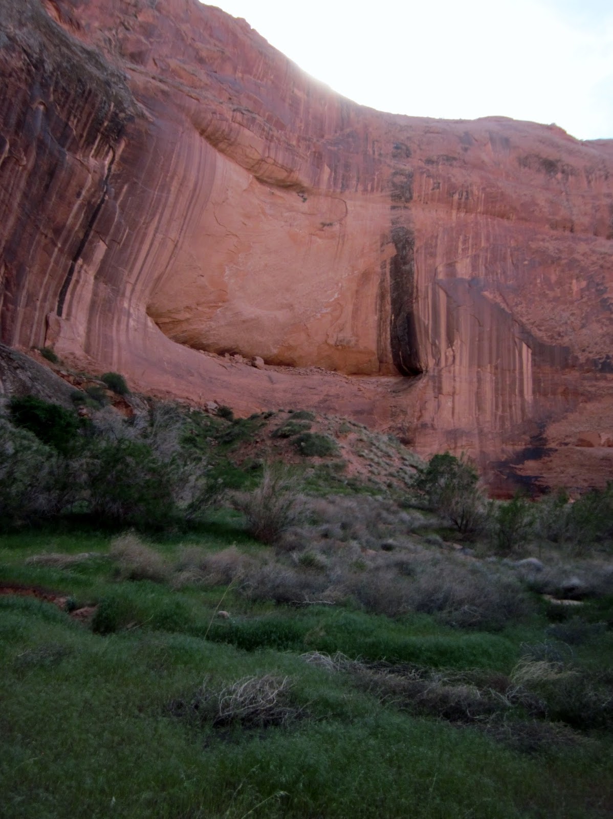
The scale of the canyon is hard to fathom. The walls are so high that our 10'6" boards were dwarfed by our surroundings. Our map showed the current water depth at over 300 feet. The high water mark (the white stripe on the rock walls) is 110' tall.
 
The farther we paddled into Cathedral, the more narrow it became until the sky was just a sliver above us and the canyon become impassable for boats. Just when we thought we were at the end, the canyon wall would open up again and shafts of sunlight would make the walls glow.
Once we hit the silty end of the water, we hiked up the canyon. The path kept twisting and opening up as we went along, making us say repeatedly, "Lets just go around one more bend..." Finally, we decided to turn around as we wanted to make it to Forbidding Canyon  at mile 49 that evening.  
 
The main channel is about one mile wide and there are red and green buoys that mark the mileage counting up from the Glen Canyon Dam at the Southern end of the Lake. We counted the number of boats that passed us on three fingers throughout the whole day and paddled hearing only the droplets of water dribble off our paddles. The turnoff for Forbidding Canyon and Rainbow Bridge National Monument came up faster than expected and we once again found ourselves pulling into the narrowing canyon as the sun started to set.
 
We pulled into the docks that mark the beginning of the 3/4m trail to Rainbow Bridge without a soul around. We tied our boards to the cleats and ran up the trail. We turned the corner and were met with dinosaur noises that stopped us in our tracks. We peered around the corner unsure of what to expect, and saw a beautiful pond filled with frogs!
 
 
The next corner gave us our first glimpse of the bridge. Sacred to neighboring American Indian tribes, the bridge stands 290 feet tall and 278 feet wide and is the second largest natural bridge in the world. There are daily tours to the bridge from Paige, 2 hours away by boat, but from the time we got there to when we left, we had it all to ourselves .
Due to the sacred nature of the site, there are signs asking people not to walk underneath the bridge, so after we spent the rest of the evening listening to the frogs and the desert.


 In the morning, we decided to hike out to the Bridge once again before we started paddling for the day. We were rewarded with the morning glow on the sandstone and the silence. When the lake was at it's highest point, 3,700' above sea level (on our trip is was 3,591') water flooded the canyon up far enough that you could drive a boat under the bridge. Hiking up to it was much more fitting.

Thursday, April 28, 2016

Lake Powell - Day 2

Day 2 - 7 Miles
What better way to start the day then with costumes. Me with my mom's old matching short suit and Carla in a classy little romper, we were ready to paddle. 
 
We headed out to the main channel with silky smooth water under our boards. As we neared the exit of the canyon we passed the morning tour boat heading to the bridge. As expected, gobs of tourists hung over the sides to take pictures of the best dressed paddlers on the lake. I hope it causes future confusion over which decade they visited the southwest.

 On to Little Oak Canyon where one of the big draws was a floating restroom. Lake Powell is fully a "pack it out" area and the idea of not carrying a couple days worth of bowel movements on our boards was always appealing. Little Oak is actually a big bay with fantastic sandy beaches and two small side canyons to explore. In the summer it is over run with houseboats, but we were the only people around.


At the end of many of the side canyons, the water is retreating enough to expose the old dead cottonwood trees. Sometimes as we paddled in you could look down into the water and see the algae covered branches reaching up towards the sky like rotting skeleton fingers. The lake is also a haven for fishermen with bass, walleyes and huge stripers drawing people from all over to try their luck. In the shallows 2' carp would slither lazily through the mud, breaching the surface and making audible popping sounds as they mouthed the surface.

Oak Canyon was fairly wide with cool grottos lining the sides and a fast moving creek running through. There are suppose to be Moki steps carved into the rock walls to allow the Anasazi to access the mesa tops, but we never found them


 Where the water level never reached the canyon floors, there were so many different kinds of flowers and grasses. Every time we turned a corner we were met with the bewitching smell of desert flowers and would fill our noses with the scents.
As dusk started to set in we headed back to camp sidestepping around little frogs and prickly pear cactus. The moon rose so bright that night, just a day away from being full, that we walked along the beaches without headlamps long after the sun went down. 


Wednesday, April 27, 2016

Lake Powell - Day 3

Day 3 - 15 miles
I spent the morning slaving away over the camp stove making French toast and omelets for breakfast- I was tired of carrying the eggs. When Carla came back from filtering water because she slept on the valve of her camel back and all her water drained out over the night, I showed her my perfect omelet, and then promptly dropped in the sand. It was still delicious.

Another glassy smooth water with no wind. We paddled effortlessly up the lake, so effortlessly that we missed Reflection Canyon by a mile and had to backtrack. Thank god we did. Reflection coils back and forth on itself so many times and each bend rises up into a spectacular amphitheater that echoes back operatic versions of Patsy Cline country music punctuated with whoops and yodels

We wound our way up the northern arm of the canyon into Cottonwood Gulch. We beached our boards on the silt and much and post holed our way through the sand to sturdier ground. We followed the creek up as it flowed over bedrock and carved it's way into deep, narrow clefts in the sandstone.


When the heat of the day was starting to make us care less and less about finding the cliff dwellings ahead, we stumbled upon an algae covered rock slide leading to sun warmed plunge pools full of sparking water. We were dogs to peanut butter, ripping off our clothes, we jumped into the sweet coolness of the sandy bottom pools and it was heavenly.

After being thoroughly refreshed, we donned our clothes and headed up the creek to find the ruins. In a short time we crossed a grassy meadow and high up in the cleft of a shady alcove we found them. In order to reach the ruins you had to climb up Moki steps about 20 feet just to reach the ledge. The Moki steps were tiny chiseled niches in the rocks that had become sloped sandy dishes over time. We were content to just hike up to the base and wonder at the people who lived here long ago.

 
When left Reflection the water was calmer then we had ever seen it and the canyon truly lived up to it's name. With our hair in wild tangles, and sand stuck in our ears we paddled up the lake to find a camping spot. Long after the sun set we beached out boards on a slickrock slope at the mouth of Llewelyn Canyon. While we were cooking dinner the moon rose up perfectly centered in a notch on the canyon wall. If I had seen this image in a painting I would have scoffed at the artist for making it too cheesy. Instead we toasted the moon with flasks of whisky chocolate bars.

Tuesday, April 26, 2016

Lake Powell - Day 4

Day 4-  7 miles. Fast paddling and lots of time outside
We woke to a windy day but fortunately it was pushing us up the lake. Unfortunately it was blowing out of the Escalante River junction in 20mph hour gusts making it impossible to paddle up the river. We decided to push onward.


Up lake at Cottonwood Canyon, we pulled off to look for Registration Rock- a wall where the 1880 Mormon wagon trail carved their names as they made their way across the river. We never found it, but we did run into an older man in waders his wife in a skimpy bikini. He asked where our boat was and when we explained what we were doing, he looked at me, looked at Carla, and said "You girls are spending a lot of time outside."
After a lengthy explanation of how to walk on slick rock, he pointed us in the direction of the route, and wished us well.
The 250 Mormon settlers left for what should have been a 3 month journey to the San Juan River in order to start a mission there. Instead of crossing at Lee's Ferry they decided to take a short cut. Unfortunately the walls of Glen Canyon were steeper and more consistent than they realized.

They decided to take their wagons and livestock down Hole in the Rock, an improbable narrow 3/4 mile cleft in the canyon wall.

It took over 6 weeks alone to blast rock, move boulders, and lay brush down in order to make the trail passable. They drove spikes into the sides of the rock wall to use as anchors for their ropes, locked the wagon wheels, and lowered each of the 80 wagons down one by one to the valley floor. Parts of the trail were at a 45 degree slope but throughout this ordeal not one person was seriously injured. Once down to the river they still had to ford their wagons across and continue on uncharted territory through Cottonwood Canyon and up to the mesa top.

Their route was 70 miles total and took 6 months, twice as long as if they had traveled via  Lee's Ferry farther to the South.

We had to scramble hand over hand in some parts of the Hole in the Rock Trail and all of a sudden we heard voices. From Escalante it is 50 mile drive on a washboard dirt road to get to the trailhead, but that didn't seem to deter anyone. We passed 3 different groups coming down the trail. Campers, kids, and dogs, all smelling much better than we did a that point.

At the top of the canyon, slickrock stretched out in all directions and the water of Lake Powell looked out of place with the desert view.
 Before the dam was finished in 1966, hikers would lower their kayaks down this trail in order to gain access to the side canyons in the area.
 We sat and watched the breeze blow ripples across the surface of the lake as we toasted our trip with lukewarm beer. With the setting sun we scurried back down the trail and hopped on our boards. We found a beach just as it was getting too dark to see the land clearly. Tired and hungry we ate and hunkered down into our sleeping bags for the night.

Monday, April 25, 2016

Lake Powell - Day 5 & 6

Day 5 - 10 miles
Over the evening the wind kicked up and we spent the night tucked deep into our sleeping bags and getting sandblasted every time we came up for air. In the morning we both had sand so deeply ingrained that our ears, hair, and eyebrows were tinted red. After a sandy cup of coffee we decided to head out onto the lake.

On Carla's suggestion we took an easy day and paddled 10 miles in 20mph wind gusts. Fortunately the wind and water weren't cold and as we neared the Rincon, our destination for the night's camping, the wind died down and the lake water become glassy smooth again.

We set up the tent in case the wind picked up again, but it was of course calm and clear all night long.

Day 6 - 6 miles
We woke up to a beautiful morning and a quick paddle out to the floating restroom before our hike around the Rincon. A Rincon used to be a horseshoe bend in the river channel but at some point the river changed course leaving a mesa top surrounded by dry land. We decided to hike around the mesa and try to find the old uranium mining camp that was abandoned when they discovered that there was no uranium. Instead the area is used every other year to graze cattle through the winter.
After hiking for hours (minutes) in the searing desert heat (70 degrees) fruitlessly searching for any signs of human industry, we found something even better, fossilized dinosaur tracks on the side of a boulder.


The tracks were listed in our book as "visible in the right kind of light" and with our record of finding notable sites, we had written it off as impossible to find. with our track record.  Thrilled with the find and satisfied with how the day was going, we turned back towards our boards and stumbled upon an old barrel, the remnants of the mining camp.  All of a sudden our day turned into a wild success and we were ecstatically overjoyed with ourselves.

The day continued to amaze. We pushed out on the main channel without a breath of wind an paddled easily to the dramatic Iceberg Canyon. For the first time we passed people camping in houseboats.

We waved to a group but they did not wave back. Since I was dressed up like Carla's creepy boyfriend that day, I wasn't entirely surprised.


 Iceberg Canyon has a natural dam in one of it's southern arms. We hiked to the top of the rock fall and were surprised to find Lake Powell trapped behind the landslide at near the high water mark. We had gotten used to seeing the white bathtub ring of bleached rock reaching over 100 feet above us, so to see it barely above the surface of the water was strange. Hiking back down to our boards we again were amazed at the scale of the canyon. Our 10' boards were just two tiny white dots on the beach.

 
The paddling was effortless that day and we found a camping spot on the main channel that we thought would put us in line with the sunrise. I hiked up the rock slabs to take a picture of our beach. Behind me and still 20' higher was an upside down buoy dangling off the top of the rocks by a cable warning shallow rocks below
After whisky and cribbage, we stretched out on our boards and tucked in for the night.


Sunday, April 24, 2016

Lake Powell - Day 7

Day 7 - 10 miles
The day started a little breezy, but we were 1 mile from Slickrock Canyon and the site of Wall Ruins so be battled our way into the canyon. We saw another group camping with a houseboat and waved as we paddled to the end of the canyon.


After about 30 minutes of hiking we found the ruins high up on the wall and fenced off from the public to protect the site. This was one of the few ruins in the canyon with the roof still intact.

As we were walking back to our boards I commented on the surprising number of birds flying around the canyon. When we made it around the bend in the creek we saw why. Ravens had found a bag of food that was strapped to Carla's board under her lifejacket. They had torn open the side of her dry bag, pulled out the baggies of dried veggies, oatmeal, and noodles and scattered them all over the beach. Worst of all, worst, worst, worst of all, the ravens had found our last two cans of precious beer and stabbed their nasty little beaks through the aluminum until the cans were riddled with holes.
We gathered all the little wrappers and pieces of trash we could find while the campers in their houseboat parked next to our boards pretended not to notice. We paddled out of the canyon in pissed off silence.

On the main channel the wind picked up to form whitecaps on the water. We knelt down on our boards and let the wind blow us forward. Instead of dissipating the wind seemed to gather speed and intensity until the nose of my board submarined under each wave and I could feel the board wobble as it tried to push back above the surface of the lake. We were at a spot in the canyon where the wall rise vertically from both sides but the wind was so intense that I doubted we could have paddled to shore if we wanted to.
 
 I looked over at Carla knowing that she isn't very comfortable with water. But instead of clinging to her board in terror as I expected, she was sitting there taking pictures and waving back at me with a grin on her face. The wind was making 2-3 foot swells on the lake and there were times when I looked over and only saw Carla's shoulders showing above the surface of the water as she dipped into a trough.
 
Fortunately, the wind pushed us directly into the canyon we were aiming for and we were able to paddle through the chop to the end of Lake Canyon where a sandy beach and a fallen cottonwood gave us a much needed camping spot and break from the wind.

After battling the wind for hours we were mentally exhausted and a little amazed that we made it. After laying on a fallen cottonwood log for a bit Carla sat up, looked around, and said "Do you want to build a fort?" With renewed energy we spent the next hour dragging logs and sticks around to make our home for the evening.
 
Later on a group came to camp on the beach near us. We walked over to say hi, eat their food, and enjoy their campfire and they told us when they first saw our fort they were convinced that a serial killer squatter was living there and almost turned around to find a new place to park their houseboat for the night. They told themselves "No one just builds a fort around their tent if they are just camping!"
 A The next morning we woke to mostly clear and calm skies and threw our packs together to see the ruins in Lake Canyon.